After three powerful coastal storms, many have grown weary of this late winter onslaught. You’re tired of the snow and I hear you. I’m here to tell you that we are in fact keeping an eye on a *potential* fourth storm for early next week. *Potential* is stressed because the social media sphere is buzzing with a “BIG STORM coming for NEPA”. While an accumulating snow is a distinct possibility, this post is intended to break down the various players of the forecast and calm some nerves. Anyone telling you Friday night, or this weekend for that matter, that they know exactly what is going to happen is a snake oil salesman. This is a complex scenario with a vast array of players. Think of this like the NFL Draft since that’s just around the corner. Every year there’s a new crop of college athletes all vying for a shot at that NFL dream. Some of those players come with very lofty expectations as to what they’re supposed to accomplish at the NFL level. Sometimes it works out… and sometimes it doesn’t. This setup for next week is very much like that. Sure – there are some “talented meteorological players” that have the potential to produce a potent storm… but that doesn’t necessarily mean that the translation is a BIG storm for our region. A storm will form… but where it goes and what it means for us is a major question and will remain that way until sometime late in the weekend or Monday morning. Let’s break this thing down.

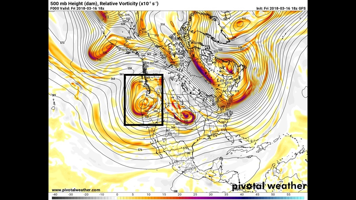
Plotted is the GFS model 500mb heights valid 2PM Friday afternoon. The boxed area is an upper level low that will eventually be part of our storm chance early next week.

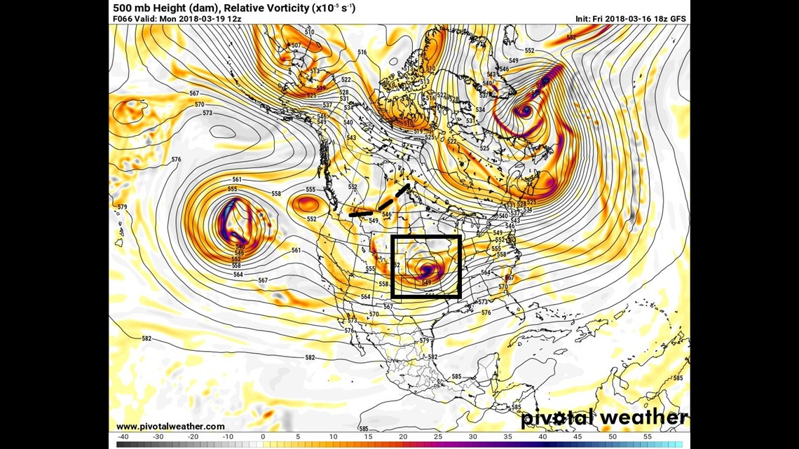
Let’s flash ahead to Monday morning. Our lead shortwave piece of energy (boxed area) has moved into the central US. The trailing shortwave trough (dashed lines) is racing to catch up. How early these two things interact will be critical in how quickly the inland surface low loses its steam and when that secondary coastal low forms, where it forms, and what it’s ultimate track may become. Already we’ve introduced a high amount of variables and we’ve only advanced 66 hours into the future.

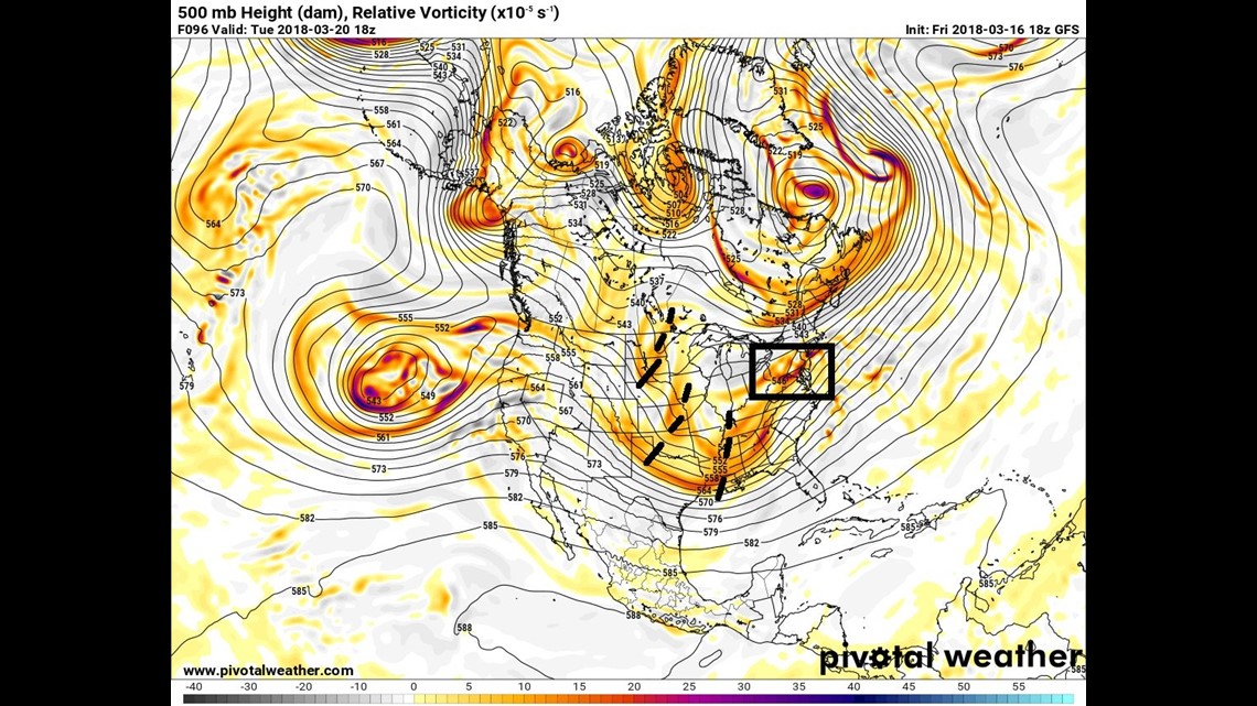
We’ve jumped ahead to Tuesday afternoon. If this model solution where to verify, that lead shortwave (boxed area) would be overhead and our region would see some form of precipitation. Note the now three trailing shortwave troughs (dashed areas) falling in behind that lead shortwave. Just how quickly these areas consolidate (if they do it all) will determine the upper level trough depth, position, and tilt, which will steer that secondary coastal low… and its potential influence on us.

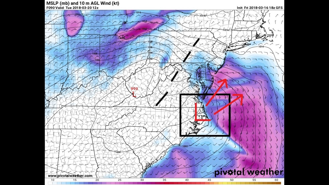
I’ve drawn in the potential region of the secondary low pressure system and what I think our two realistic tracks are at this point. It would appear that it either stays close to the coast or heads out over the fish. Closer to the coast, more impact for us… over the fish – not our problem.
Important Read:
All of this DOESN’T mean that we have no idea what’s going on. This post is meant to show the vast amount of variables that are going into the forecast and how if just one of them moves differently than currently forecast, the ENTIRE scenario plays out differently. As we get closer to the event, the hope is to find some better continuity among the models because right now… it’s like darts at a dart board.
Hang in there. Be sure to enjoy your St. Patrick’s Day weekend because that looks beautiful. A little luck of the Irish playing in our favor.
Stormtracker 16 Meteorologist John Hickey


