

It’s hard to believe that Christmas is just a little over a week away. Where did 2017 go? That’s a totally separate question from the usual suspects this time of year. Those questions being will it snow on Christmas and/or will it be a white Christmas? As the title to this edition of “Beyond the 7-day” suggests, it’s not a clear cut answer.
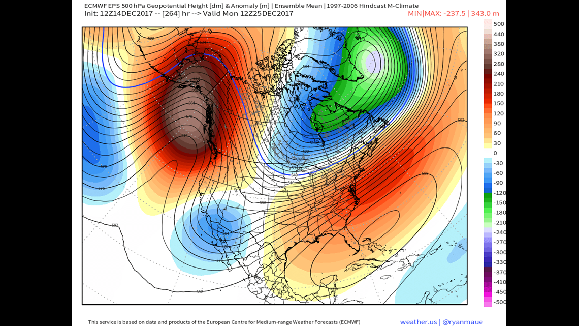
The image above shows the 500mb height anomaly for Christmas Day… which is basically saying what the jet stream pattern will look like compared to the average for Christmas Day. A quick glance shows the same general pattern that we’ve been firmly entrenched in for the past week. There’s a ridge in the west and a trough towards the East. However, notice the shift? That ridge is no longer centered over the western US but rather the eastern Pacific. The trough is over the Great Plains and much of the Northeast is on the tight gradient between colder air to the north and warmer air to the south. Check out how it shakes out in your two meter temperature anomaly map below.


Living on the tight gradient between warmer and colder air with a storm track from the southwest puts not only Pennsylvania, but the entire Northeast in a precarious situation. This type of setup basically acts like a “storm highway” for storms to ride on. But does it rain… snow… icy mix? Is there a storm at all? Much of our longer range guidance has been suggesting that a storm is in our neck of the woods between the 24th and 26th. Not ideal if you’re traveling. But does this come to fruition?

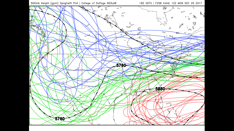
The map above looks like a bowl of spaghetti. Not surprisingly, it’s known as a spaghetti plot. It shows individual ensemble members of the GFS computer model along with the mean position of various 500mb heights forecast valid Christmas Day. The takeaway here is that the “storm highway’s” path is FAR from carved in stone. Any social media post or otherwise claiming to know what the forecast is for Christmas is right now is really just grasping at straws.
What you should do, as you likely always do when a major travel period is coming up, is keep an eye on the forecast as it changes and evolves. We’ll have a much better idea about Christmas by the middle of next week. Until then, stay warm!
Stormtracker 16 Meteorologist John Hickey