

We’re entering prime season for Lake Effect snow events and the first decent one of the season could be coming up for the second half of the weekend and into early next week. A low pressure system lifting to our north on Saturday will push some rain showers through Central and Northeast Pennsylvania. A cold front comes through Saturday night dropping temperatures significantly for Sunday and Monday.
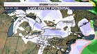
There are many factors that go into just how significant a Lake Effect snow event is. Arguably the two biggest are:
- The difference between the Great Lakes temperatures and the air that’s moving ~5,000 feet over them.
- The wind direction.
As it stands now, the temperature differential (23 degrees between the water and the air 5,000 feet overhead) will likely be met. The biggest thing to watch going forward is the position of the upper level low as that will drive the wind direction in the lower atmosphere. Depending on that wind direction, a “lake-to-lake” connection would be possible which would push the Lake Effect snow bands further inland.
While Lake Effect snow events typically have minimal widespread impacts locally in terms of heavy snow accumulation, certainly things like snow squalls would be a concern. The areas to watch at this point would be the typical Lake Effect snow belts like the Tug Hill where the most significant snow usually falls. Perhaps some folks will be able to get on the snowmobiles before the turkey comes out of the oven on Thanksgiving!
Stormtracker 16 Meteorologist John Hickey