

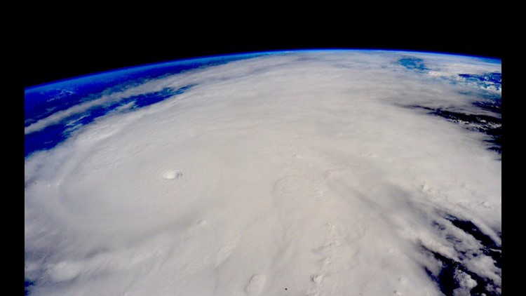

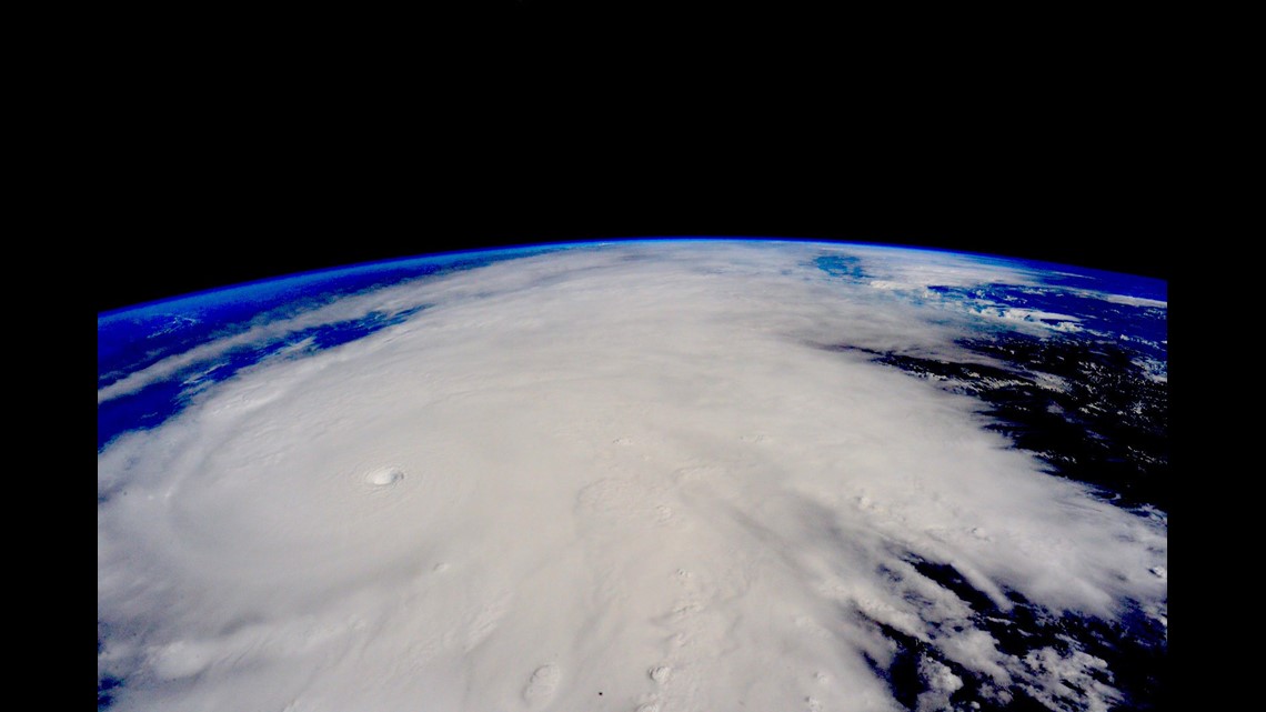
Astronaut Scott Kelly tweeted an incredible photo of Hurricane Patricia from the International Space Station on Friday.
“Stay safe below, Mexico,” Kelly tweeted.
Patricia — the strongest hurricane ever recorded — barreled closer and closer Friday to Mexico’s Pacific coast, where residents have been told to brace for its 200-mph sustained winds and torrential rains.
The excessive wind speeds, according to the head of the Mexican agency that includes its national weather service, “makes Patricia the most dangerous storm in history.”
By that, CONAGUA director Robert Ramirez de la Parra meant any cyclone ever measured not just in and around Mexico, but anywhere in the world.
Ramirez de la Parra predicted Hurricane Patricia will make landfall somewhere on the coast of Jalisco state — which includes the tourist hotspot of Puerto Vallarta and is also close to Manzanillo and Colima — between 5 and 6 p.m. CT (6 and 7 p.m. ET). But its impact should be felt much sooner, with 100 kph (62 mph) winds lashing the region in the early afternoon.
While its strength could fluctuate, “Patricia is expected to remain an extremely dangerous Category 5 hurricane through landfall,” the U.S. National Weather Center said in its 10 a.m. CT advisory.
Already, Patricia is “the strongest hurricane on record in the National Hurricane Center’s area of responsibility (AOR) which includes the Atlantic and the eastern North Pacific basins,” according to a Friday morning forecast discussion.
The closest contender, at this point, might be Hurricane Camille when it battered the U.S. Gulf Coast in 1969. Regardless, Patricia looks to be more powerful than that storm, as well as stronger than Hurricane Andrew in 1992, Katrina in 2005 and many others.
It’s already surpassed them in one way: its central pressure reading — the weight of the air above a system — which is a key measure of any storm’s strength.
The early Friday central pressure recording of 880 millibars (the barometric pressure equivalent is 25.98 inches) “is the lowest for any tropical cyclone globally for over 30 years,” according to the Met Office, Britain’s weather service.
Patricia’s intensity is comparable to Typhoon Haiyan, which hit the Philippines in 2013, the World Meteorological Organization tweeted. More than 6,000 people died in Haiyan, due largely to enormous storm surges that rushed through coastal areas. Haiyan had 195-mph sustained winds when it made landfall, while Typhoon Tip was at 190 mph (and had a slightly lower pressure reading of 870 millibars) in 1979.
Whether or not Patricia measures up to those Asian typhoons when it slams Mexico, CNN meteorologist Chad Myers said, “This is the only hurricane that’s ever been this powerful.”
Life-threatening flash floods, surf
Late Friday morning, the storm was centered 125 miles (75 kilometers) southwest of Manzanillo, Mexico, and 195 miles south of Cabo Corrientes.
Moving at a 10-mph clip, it’s forecast to pivot north-northeast later Friday and pick up speed — especially after it makes landfall, when Patricia should both accelerate and “rapidly weaken over the mountains of Mexico.”
A hurricane warning, which means hurricane conditions were expected within 24 hours, extends from San Blas to Punta San Telmo. A larger area, from east of Punta San Telmo to Lazaro Cardenas, is under a hurricane watch.
In addition to powerful winds, concerns are high about dangerous storm surges like those that overran the Filipino city of Tacloban during Haiyan. The National Hurricane Center warned about those as well as swells that “are likely to cause life-threatening surf and rip-current conditions.”
Rainfall of 8 to 12 inches — and possibly 20 inches in some spots — “could produce life-threatening flash floods and mudslides,” according to the U.S. weather agency.
All of that adds up to millions of people, some of them tourists who’d gone to the coast to get away, under threat.
Mexican authorities take preventive measures
Mexican authorities responded with a full-court press Friday to get the word out, as well as to get resources deployed to the right places ahead of the storm.
In a meeting that started Thursday night and extended into Friday morning, President Enrique Pena Nieto directed members of his cabinet to take immediate action in the face of what was then predicted to be the strongest hurricane in the eastern Pacific in the past 50 years, according to the official Notimex news agency.
The most dire warnings went to those the states of Jalisco, Colima, Nayarit, Michoacan and Guerrero, where people were told to get ready by heading to shelters, staying home from school or doing what they could to be safe wherever they are. The Mexican presidency noted, via Twitter, that waterspouts and tornadoes could pop up as Patricia rampages through.
Mexico’s civil protection agency tweeted that over 1,780 shelters had been set up and that a 50,000-strong force has been mobilized in Jalisco, Colima and Nayarit alone. In addition, about 4,000 Mexican navy officers have been dispatched to areas expected to bear the brunt of Patricia’s wrath.
All flights to and from the airports in Puerto Vallarta and Manzanillo were suspended, and all banks in certain locales shut down at noon, according to Mexico’s civil protection agency.
That agency noted the gas company PEMEX planned to suspend all gas sales in the cities of Manzanillo and Colima, while the Comision Federal de Electricidad planned to cut off electricity — as a precaution — at 1 p.m. (2 p.m. ET) in cities in Colima, Jalisco and Nayarit.
Some hotels in Puerto Vallarta were evacuated, though others — like the Comfort Inn, where manager Samuel Ruic said windows were being boarded up with tape — were not. And locals did what they could by boarding up windows and piling up sand bags along beaches in places such as Manzanillo in hopes of blunting what’s expected to be a colossal storm surge.
Ramirez de la Parra, the Mexican official, warned people not to get complacent as the storm passes. That’s especially true for those who end up in the storm’s eye, where there often is “apparent calm.”
“It’s the walls of the (hurricane’s) eye where you can find the (greatest) wind intensity,” he said. “… The heaviest damage is after the hurricane passes. We must wait until (the passage of) the entire body of the hurricane in order to call off the preventive (measures).”
El Nino contributes to storm’s strength
One other thing alarming about Patricia is its rapid rise in intensity. It rated as a tropical storm early Thursday, but 24 hours later it had become a Category 5 hurricane.
The storm is expected to roll over Mexico’s Sierra Madre, likely significantly dulling its intense winds in the process. But much of the system’s precipitation should roll on — potentially up to Arkansas, Louisiana and Texas, a state that’s now facing 3 to 6 inches in many areas from another system.
Still, while the Patricia-related rainfall could be significant in the United States, it pales to what people in Mexico will experience.
Those on that Latin American country’s west coast are no stranger to tropical storms, of course. But Patricia is special, in part because of the global, regular weather phenomenon known as El Niño.
Among other effects, El Niño has contributed to ocean waters off Mexico being 2 to 3 degrees warmer than usual.
“That warm water from El Niño probably just pushed this slightly over the edge to be the strongest storm on record,” CNN’s Myers said.
About the only good news about Patricia, as of Friday morning, was that its center was fairly compact, with hurricane-force winds only extending 30 miles out from its eye.
That’s a plus for anyone who gets brushed by the hurricane, but no consolation for those who get hit directly.
“That’s almost like an F4 or F5 tornado that can be 5 or 6 miles wide, just tearing up the coast as it makes landfall,” said Myers. “… Can you imagine being the center of this eye, … and then get hit by the eye wall doing 200 mph?
“It will be a devastating blow.”