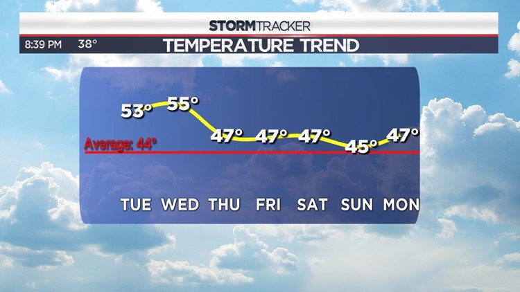
December starts Friday which marks the start of meteorological winter. The Full Cold Moon rises on Sunday further exemplifying what December is all about. It’s not our coldest or snowiest month on average (that’s January), but it traditionally marks the beginning of a cold and snowy stretch much to the delight of winter weather lovers… and chagrin of those who long for warm summer days. The end of November and first days of December look rather warm. Check out the forecast high temperatures for the next seven days below.
The warmth over the week ahead has a lot to do with the relative transient nature of our jet stream pattern. Remember, the jet stream is that thin ribbon of air high in the sky that steers storm systems around and separates various air masses. Right now, we’re in more or less a “zonal flow pattern”. An example of what that looks like is below.
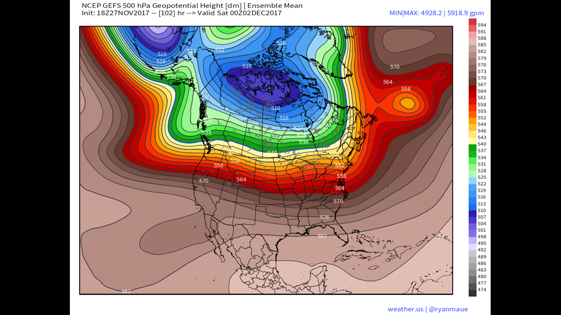
Pictured above is a GFS 500mb Ensemble Mean Forecast for Friday night. The important thing to note here is that the lines moving through the US are rather straight. You don’t see any big dips (troughs) or ridges, rather the lines are relatively flat across the lower 48. This is a text book example of “zonal flow”. Under these conditions, relatively weak storm systems zip across the US with very little fanfare. Temperatures generally run near average with only short stretches of above average warmth or below average cold as little “bumps” form in the flow. However, this is due to change during the first full week of December.
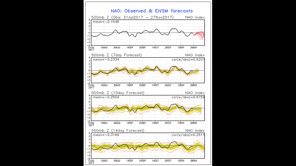
Pictured above are forecasts for the NAO (North Atlantic Oscillation) and PNA (Pacific North American oscillation). Meteorologists use these indices to determine how “blocky” our weather pattern gets and how willing cold air is to descend from the Arctic. When the NAO is in a negative phase, our weather pattern becomes an atmospheric traffic jam. When the PNA is in a positive phase, cold air is more willing to descend from the Arctic into the Eastern US. Current model forecasts suggest that the NAO will trend negative and the PNA will trend positive during the start of December.
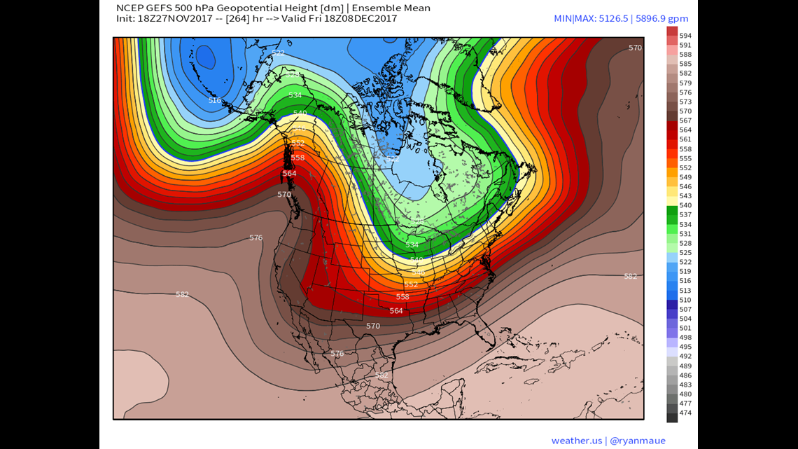
The two pictures shown above are two different Ensemble model forecasts for Friday December 8th. Notice how different our flow pattern is from what we’re seeing this week. Long gone is that “zonal flow”. It has been replaced by major ridges and troughs which is consistent with the NAO and PNA oscillation forecasts. Both model forecasts would result in considerably cooler air across the Eastern US and would at least open the door to some more “juicy” storms thanks to the orientation of the jet stream flow.
All of this is to say that winter weather lovers *might* enjoy what is to come for early to mid-December. While it’s much too early to call for any individual storm this far out, the “window of opportunity” certainly appears to be presenting itself for an active start to meteorological winter.
Stormtracker 16 Meteorologist John Hickey